Non-Technical Description
The maps are based on data from NASA's Gravity Recovery and Climate Experiment (GRACE; 2002-2017) and GRACE Follow On (GRACE-FO; 2018-present) satellites, which detect small changes in the Earth's gravity field caused by the redistribution of water on and beneath the land surface. The paired satellites travel about 137 miles (220 km) apart at an altitude of 300 miles (485 km) and record small changes in the distance separating them as they encounter variations in the Earth's gravitational field.
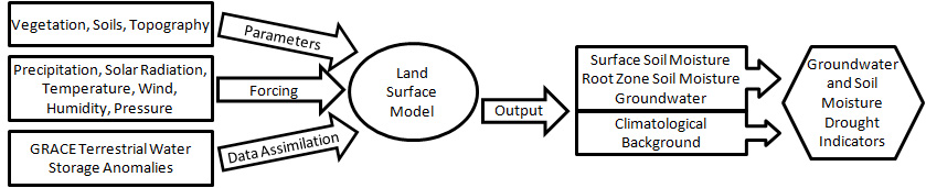
To make the maps, scientists use a sophisticated computer model that combines measurements of water storage anomalies from GRACE and GRACE-FO with a long-term meteorological dataset to generate a continuous record of soil moisture and groundwater that stretches back to 1948. The meteorological data include precipitation, temperature, solar radiation and other ground- and space-based measurements.
Differences between the CONUS and Global/North American maps are expected because the meteorological data used to force the land surface model are different for the two products. The CONUS forcing is from the North American Land Data Assimilation System version 2 (NLDAS2), which is based on the NOAA/NCEP North American Regional Reanalysis and corrected with gauge and Doppler radar rain data and other observations. The global forcing is atmospheric analysis data from the European Centre for Medium Range Weather Forecasts.
Technical Description
Launched in 2002, NASA’s Gravity Recovery and Climate Experiment satellites were unique in their ability to measure variations in water stored at all levels above and within the land surface (terrestrial water storage). The GRACE mission ended in 2017, but the data record is now being extended by the GRACE-FO mission, which launched on May 22, 2018. The spatial (>150,000 km2) and temporal (monthly with a significant time lag) resolutions of the GRACE and GRACE-FO fields limit their direct applicability for drought assessment. In order to increase the resolution, eliminate the time lag, and isolate groundwater and other components from total terrestrial water storage, scientists at NASA/GSFC integrate the GRACE and GRACE-FO data with other ground- and space-based meteorological observations (precipitation, solar radiation, etc.) within the Catchment Land Surface Model, using Ensemble Kalman smoother type data assimilation (Zaitchik et al., 2008, Kumar et al., 2016). The resulting fields of soil moisture and groundwater storage variations are then used to generate drought indicators based on the cumulative distribution function of wetness conditions during 1948-2014 simulated by the Catchment model. Houborg et al. (2012) provide complete details on U.S. GRACE-based drought indicator product generation. Li et al. (2019) provide details on global GRACE and GRACE-FO data assimilation and drought indicator product generation. Getirana et al. (2020) provide details on CONUS drought/wetness forecast product generation.
Acknowledgements
Development and production of these drought/wetness indicator maps has been supported by NASA’s Terrestrial Hydrology Program, NASA's Applied Science - Water Resources Program, and NASA's GRACE and GRACE-FO Science Team. We also thank the European Centre for Medium-range Weather Forecasts (ECMWF) for atmospheric analysis data that are a crucial model input
Preferred Citations
Please cite
Houborg et al. (2012) for the U.S. drought/wetness indicators.
Li et al. (2019) for the global drought/wetness indicators.
Getirana et al. (2020) for the U.S. drought/wetness forecasts.
If using maps and data please use
Data / maps available at nasagrace.unl.edu through a partnership with the National Drought Mitigation Center.
References
Getirana, A., M. Rodell, S. Kumar, H.K. Beaudoing, K. Arsenault, B. Zaitchik, H. Save, and S. Bettadpur, GRACE improves seasonal groundwater forecast initialization over the U.S., J. Hydrometeor., 21 (1), 59-71, doi:10.1175/JHM-D-19-0096.1, 2020.
Li, B., M. Rodell, S.V. Kumar, H.K. Beaudoing, A. Getirana, B.F. Zaitchik, L.G. Goncalves, C. Cossetin, S. Bhanja, A. Mukherjee, S. Tian, N. Tangdamrongsub, D. Long, J. Nanteza, J. Lee, F. Policelli, I. B. Goni, D. Daira, M. Bila, G. de Lannoy, D. Mocko, and S. C. Steele-Dunne, Global GRACE data assimilation for groundwater and drought monitoring: advances and challenges, Water Resour. Res., 55, doi:10.1029/2018WR024618, 2019.
Kumar, S.V., B.F. Zaitchik, C.D. Peters-Lidard, M. Rodell, R. Reichle, B. Li, M. Jasinski, D. Mocko, A. Getirana, G. De Lannoy, M. Cosh, C.R. Hain, and M. Anderson, Assimilation of gridded GRACE terrestrial water storage estimates in the North American Land Data Assimilation System, J. Hydrometeor., 17, 1951-1972, DOI: 10.1175/JHM-D-15-0157.1, 2016.
Houborg, R., M. Rodell, B. Li, R. Reichle, and B. Zaitchik, Drought indicators based on model assimilated GRACE terrestrial water storage observations, Wat. Resour. Res., 48, W07525, doi:10.1029/2011WR011291, 2012.
Zaitchik, B.F., M. Rodell, and R.H. Reichle, Assimilation of GRACE terrestrial water storage data into a land surface model: results for the Mississippi River Basin, J. Hydrometeor., 9 (3), 535-548, doi:10.1175/2007JHM951.1, 2008.
More Information
For further information please contact Matthew.Rodell-at-nasa.gov